
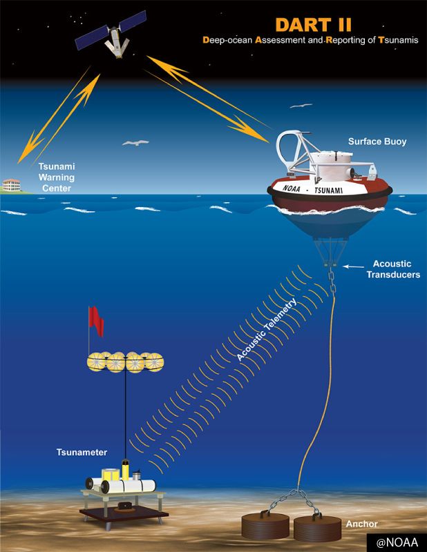
DART II Tsunami Warning System
The Deep-ocean Assessment and Reporting of Tsunamis (DART II) is an advanced system developed by NOAA (National Oceanic and Atmospheric Administration) to detect and monitor tsunamis in real-time, improving early warning capabilities to save lives and reduce property damage. It is a critical component of global tsunami warning systems, particularly in regions prone to tsunamis like the Pacific Ocean.
Key Features and Components
System Design:
A DART II station consists of a seafloor bottom pressure recorder (BPR) and a surface buoy. The BPR measures water pressure changes (as small as 1 mm in sea level) caused by passing tsunami waves, which are transmitted via acoustic telemetry to the surface buoy. The buoy then relays data to satellites (primarily Iridium) for real-time dissemination to Tsunami Warning Centers (TWCs).
The surface buoy is a 2.5-meter fiberglass disk with foam, weighing about 4,000 kg, moored by a strong 19 mm nylon line with a 7,100 kg tensile strength.
Two-Way Communication:
Unlike its predecessor, DART I, which used one-way communication via GOES satellites and relied on automatic tsunami detection, DART II (operational since 2005) features two-way communication via the Iridium satellite system. This allows TWCs to manually trigger event mode for high-resolution data (15-second intervals) or retrieve data for analysis, reducing false positives and enabling detection of smaller tsunamis.
Monitoring Modes:
Standard Mode: Records sea-level height every 15 minutes, transmitting data hourly (four observations).
Event Mode: Triggered automatically by a pressure change (e.g., 3 cm) or manually by TWCs, it sends 15-second data for up to three hours, providing detailed tsunami wave information.
Development and Deployment
History:
Developed by NOAA’s Pacific Marine Environmental Laboratory (PMEL), the first DART prototype was deployed in 1995 off Oregon. DART I became operational in 2003, and DART II upgrades began in 2005, with all stations converted by 2008.
The 2004 Indian Ocean tsunami spurred global expansion, leading to 39 U.S.-operated DART II stations by 2008 across the Pacific, Atlantic, and Caribbean, with additional stations deployed by countries like Australia, Chile, Indonesia, and Thailand.
Global Impact:
DART II data is shared internationally via the Global Telecommunications System (GTS) and archived by NOAA’s National Centers for Environmental Information (NCEI). It supports tsunami forecasting models like the Method of Splitting Tsunamis (MOST), improving wave height and arrival time predictions.
Functionality
Tsunami Detection: The BPR detects pressure changes from tsunami waves, which are distinct from faster-moving earthquake waves. When a tsunami is detected, the system switches to event mode, sending rapid updates to TWCs in places like Hawaii, Alaska, or New Zealand’s National Geohazards Monitoring Centre (NGMC).
Forecasting: Data is integrated with seismic information and pre-computed models to refine tsunami source estimates, predicting coastal impacts. For example, in New Zealand, DART stations can provide 2.5-3 hours of warning for distant tsunamis.
Applications: Used by NOAA’s Tsunami Warning Centers, the Pacific Tsunami Warning Centre (PTWC), and international systems like India’s INCOIS, DART II enhances warning accuracy, reducing false alarms and enabling timely evacuations.
Challenges and Reliability
Maintenance: DART II systems face harsh ocean conditions, leading to reliability issues. A 2010 report noted that only 60% of 39 U.S. stations were operational by 2009 due to rapid deployment and insufficient testing. Maintenance costs are high (around $300,000 per buoy annually), and budget cuts have slowed improvements.
Improvements: The system’s design allows remote configuration and uses acoustic release mechanisms for easier recovery. Dual modems and redundant communication systems enhance reliability.
Impact and Significance
DART II has revolutionized tsunami forecasting by providing real-time, deep-ocean data, enabling more accurate and timely warnings compared to earlier earthquake-centric systems. For instance, it helped avoid unnecessary evacuations during a small Alaskan tsunami in 2004.
The system is critical for regions like the Pacific, where 76% of fatal tsunamis occur, and supports global efforts through UNESCO-IOC and national agencies like New Zealand’s NEMA.
Tell us how can we improve this post?

Hi I am Marcus, MM0ZIF, a licenced Radio Amateur, Doctor of Musicology, amateur weather enthusiast. I over the years have been a Amateur Radio Tutor, Examiner, and a Regional Manager for the Radio Society of Great Britain.
This site is dedicated more towards Amateur Radio and Weather, with an angle on Technology too. I also maintain https://havenswell.com/ which is my other blog which is more aimed at cooking, hobbies and life in general as well as businness and networking.
- MM0ZIF
- MM0ZIF
- MM0ZIF

- MM0ZIF

- MM0ZIF
- MM0ZIF
- MM0ZIF
- MM0ZIF
- MM0ZIF
- MM0ZIF


