
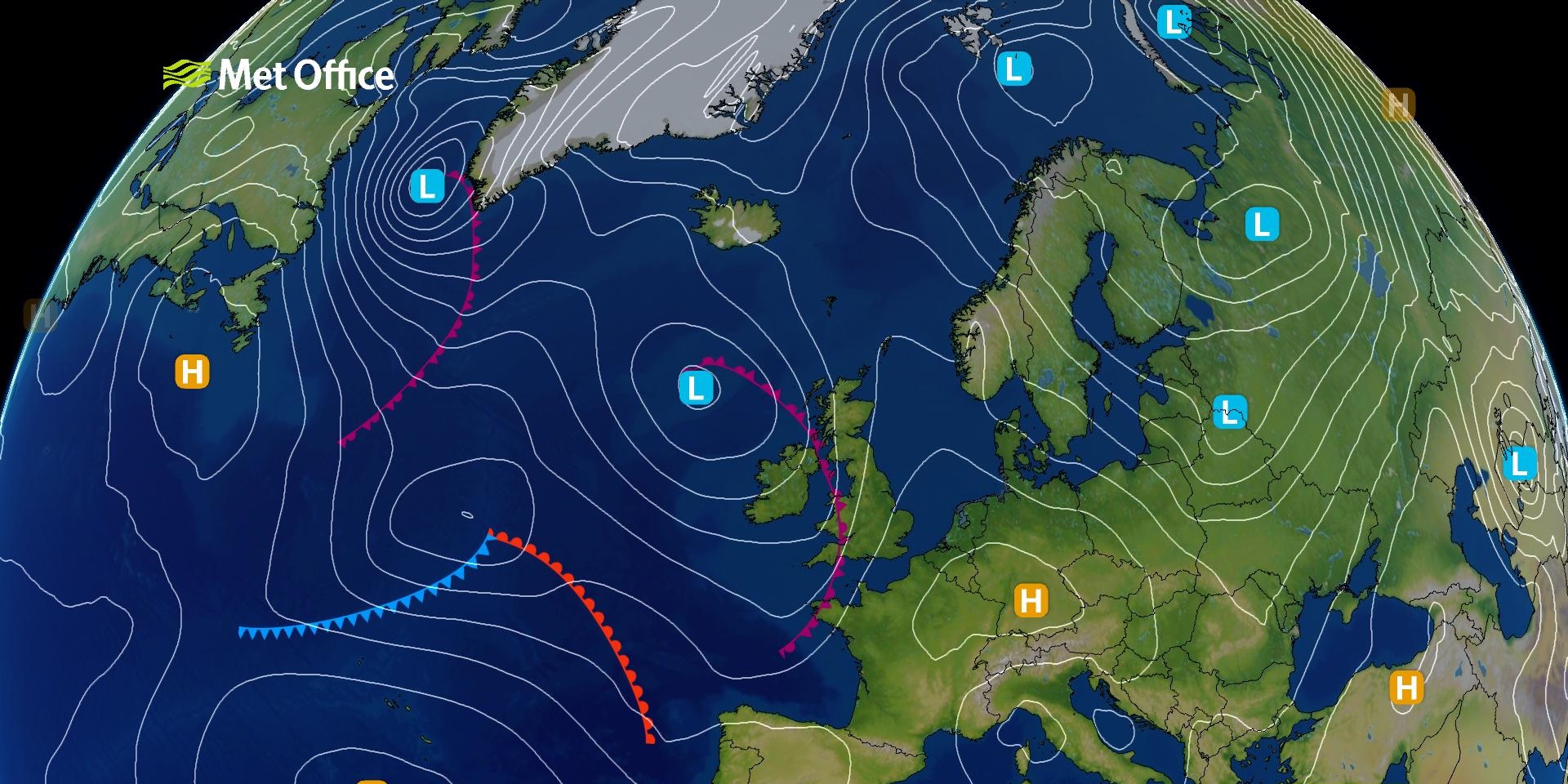
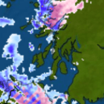
Isobars are lines drawn on weather maps that connect points of equal atmospheric pressure. These lines are typically measured in hectopascals (hPa) or millibars (mb), with standard sea-level pressure defined as 1013 hPa Science Focus. By analyzing isobars, meteorologists can identify high and low-pressure systems, which are crucial for predicting weather conditions.
Interpreting Isobars on Weather MapsUnderstanding the patterns formed by isobars can reveal much about current and upcoming weather:
Spacing of Isobars: Closely spaced isobars indicate a steep pressure gradient, leading to stronger winds. Conversely, widely spaced isobars suggest a gentle pressure gradient and lighter winds Meteomatics.
Pressure Systems:
High-Pressure Areas (Anticyclones): Represented by isobars with higher pressure values at the center, these areas are generally associated with clear skies and calm weather.
Low-Pressure Areas (Depressions): Characterized by isobars with lower pressure values at the center, these regions often bring clouds, precipitation, and unsettled weather.
Wind Direction: In the Northern Hemisphere, winds circulate clockwise around high-pressure systems and counterclockwise around low-pressure systems. The opposite occurs in the Southern Hemisphere
Practical Applications of IsobarsIsobars are invaluable for various stakeholders:
Meteorologists: Use isobar patterns to forecast weather changes, such as the approach of storms or the development of calm conditions.Aviation and Maritime Operations: Pilots and sailors rely on isobar maps to assess wind conditions and plan safe routes.
General Public: Understanding isobars can help individuals anticipate weather changes, such as identifying potential windy conditions when isobars are closely spaced.
ConclusionIsobars serve as a fundamental component in the visualization and interpretation of atmospheric pressure on weather maps. By analyzing their patterns, one can gain valuable insights into wind behavior, pressure systems, and overall weather conditions. Whether you’re a meteorologist, a pilot, or simply someone interested in the weather, understanding isobars enhances your ability to interpret and anticipate atmospheric changes.
| Symbol | Description |
|---|---|
| Isobars | Lines connecting points of equal atmospheric pressure (measured in hPa or mb). Show pressure patterns. (Met Office, Met Office) |
| High (“H”) | Denotes the centre of a high-pressure (anticyclone) area—generally associated with dry, calm weather. (The Bureau of Meteorology, Wikipedia) |
| Low (“L”) | Marks the centre of a low-pressure (depression/cyclone) area—often bringing windier, unsettled weather. (The Bureau of Meteorology, Wikipedia) |
| Cold front | Blue line with triangles pointing in the direction of movement; indicates encroaching cooler air. (Met Office, ThoughtCo) |
| Warm front | Red line with semicircles pointing in the direction of movement; marks incoming warmer air. (Met Office, ThoughtCo) |
| Occluded front | Purple line with alternating triangles and semicircles; forms when a cold front overtakes a warm front. (MetLink – Royal Meteorological Society, ThoughtCo) |
| Stationary front | Alternating red semicircles and blue triangles on opposite sides; indicates little or no movement. (ThoughtCo) |
| Trough | A plain black dashed or unadorned line—not a front; shows an elongated area of low pressure and instability. (Met Office, MetLink – Royal Meteorological Society) |
| Pressure gradient (spacing) | Closely spaced isobars = strong winds; widely spaced isobars = lighter winds. (Met Office, Met Office) |
| Wind flow around systems | In the Northern Hemisphere: Winds flow anticlockwise around lows and clockwise around highs. (Met Office, MetLink – Royal Meteorological Society) |
Tell us how can we improve this post?

Hi I am Marcus, MM0ZIF, a licenced Radio Amateur, Doctor of Musicology, amateur weather enthusiast. I over the years have been a Amateur Radio Tutor, Examiner, and a Regional Manager for the Radio Society of Great Britain.
This site is dedicated more towards Amateur Radio and Weather, with an angle on Technology too. I also maintain https://havenswell.com/ which is my other blog which is more aimed at cooking, hobbies and life in general as well as businness and networking.
- MM0ZIF

- MM0ZIF
- MM0ZIF

- MM0ZIF

- MM0ZIF

- MM0ZIF
- MM0ZIF
- MM0ZIF
- MM0ZIF
- MM0ZIF

- MM0ZIF

- MM0ZIF

- MM0ZIF
- MM0ZIF
- MM0ZIF
- MM0ZIF

- MM0ZIF
- MM0ZIF

- MM0ZIF

- MM0ZIF

- MM0ZIF
- MM0ZIF
- MM0ZIF

- MM0ZIF

- MM0ZIF

- MM0ZIF

- MM0ZIF

- MM0ZIF

- MM0ZIF
- MM0ZIF
- MM0ZIF

- MM0ZIF

- MM0ZIF

- MM0ZIF
- MM0ZIF
- MM0ZIF
- MM0ZIF

- MM0ZIF
- MM0ZIF
- MM0ZIF
- MM0ZIF
- MM0ZIF

- MM0ZIF

- MM0ZIF
- MM0ZIF
- MM0ZIF

- MM0ZIF

- MM0ZIF
- MM0ZIF

- MM0ZIF
- MM0ZIF

- MM0ZIF
- MM0ZIF
- MM0ZIF

- MM0ZIF
- MM0ZIF
- MM0ZIF

- MM0ZIF

- MM0ZIF

- MM0ZIF

- MM0ZIF
- MM0ZIF

- MM0ZIF
- MM0ZIF
- MM0ZIF

- MM0ZIF

- MM0ZIF

- MM0ZIF

- MM0ZIF

- MM0ZIF

- MM0ZIF

- MM0ZIF

- MM0ZIF

- MM0ZIF

- MM0ZIF

- MM0ZIF

- MM0ZIF

- MM0ZIF

- MM0ZIF
- MM0ZIF
- MM0ZIF

- MM0ZIF

- MM0ZIF

- MM0ZIF

- MM0ZIF

- MM0ZIF
- MM0ZIF
- MM0ZIF
- MM0ZIF
- MM0ZIF
- MM0ZIF
- MM0ZIF
- MM0ZIF
- MM0ZIF
- MM0ZIF
- MM0ZIF
- MM0ZIF

- MM0ZIF

- MM0ZIF

- MM0ZIF

- MM0ZIF

- MM0ZIF

- MM0ZIF

- MM0ZIF

- MM0ZIF
- MM0ZIF

- MM0ZIF

- MM0ZIF

- MM0ZIF

- MM0ZIF

- MM0ZIF
- MM0ZIF

- MM0ZIF

- MM0ZIF

- MM0ZIF

- MM0ZIF
- MM0ZIF

- MM0ZIF

- MM0ZIF

- MM0ZIF
- MM0ZIF

- MM0ZIF

- MM0ZIF

- MM0ZIF
- MM0ZIF
- MM0ZIF
- MM0ZIF
- MM0ZIF

- MM0ZIF
- MM0ZIF
- MM0ZIF

- MM0ZIF
- MM0ZIF
- MM0ZIF
- MM0ZIF

- MM0ZIF

- MM0ZIF
- MM0ZIF
- MM0ZIF

- MM0ZIF

- MM0ZIF

- MM0ZIF

- MM0ZIF

- MM0ZIF
- MM0ZIF
- MM0ZIF

- MM0ZIF

- MM0ZIF
- MM0ZIF

- MM0ZIF
- MM0ZIF
- MM0ZIF
- MM0ZIF

- MM0ZIF
- MM0ZIF
- MM0ZIF

- MM0ZIF
- MM0ZIF

- MM0ZIF

- MM0ZIF
- MM0ZIF
- MM0ZIF
- MM0ZIF

- MM0ZIF
- MM0ZIF
- MM0ZIF

- MM0ZIF

- MM0ZIF
- MM0ZIF

- MM0ZIF
- MM0ZIF

- MM0ZIF
- MM0ZIF
- MM0ZIF
- MM0ZIF

- MM0ZIF
- MM0ZIF

- MM0ZIF
- MM0ZIF


