
Sting jets are one of the most fascinating yet least understood phenomena in meteorology. These powerful bursts of wind occur within certain extratropical cyclones and can cause devastating damage over small, localized areas. In this article, we’ll explore what sting jets are, how they form, and why understanding them is crucial for improving weather forecasting and protecting communities.
What Is a Sting Jet?
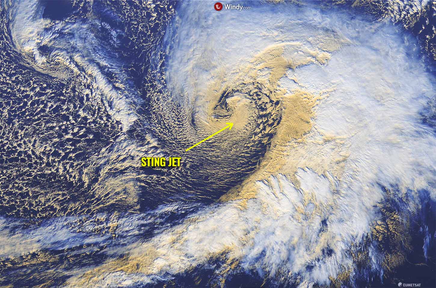
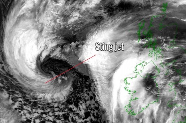
A sting jet is a narrow corridor of exceptionally strong winds that can develop in the later stages of an extratropical cyclone. These winds can reach speeds of over 160 kilometers per hour (100 mph), equivalent to a Category 1 hurricane, but are far more localized. The term “sting jet” comes from its appearance on satellite imagery, where it resembles the sting in the tail of a scorpion.
While extratropical cyclones are common in mid-latitude regions like the North Atlantic, sting jets are relatively rare. However, their destructive potential makes them an important area of study for meteorologists.
How Do Sting Jets Form?
The formation of a sting jet involves a complex interaction of atmospheric processes:
- Cyclone Intensification: An extratropical cyclone develops as warm and cold air masses collide, creating a large-scale rotating storm system.
- Cloud Head Formation: A dense region of cloud, known as the cloud head, forms around the cyclone’s low-pressure center. This wraps around the storm as it intensifies.
- Dry Intrusion: Dry air from the upper atmosphere or stratosphere descends into the storm, interacting with the moist air in the cloud head. This causes evaporative cooling, making the air denser and accelerating its descent.
- Sting Jet Development: The accelerated air forms a narrow band of intense winds near the tip of the cloud head. This jet descends toward the surface, unleashing destructive winds over a localized area.
Sting jets typically last for only a few hours but can cause severe damage, including uprooting trees, damaging buildings, and disrupting infrastructure.
The Science Behind Sting Jets
Sting jets are driven by a combination of dynamic and thermodynamic processes. The dry intrusion plays a key role in destabilizing the atmosphere, while evaporative cooling amplifies the descent of air. These factors create a feedback loop, intensifying the wind speeds.
Sting jets occur in the so-called “wrap-around” phase of a cyclone, when the cloud head curves around the storm’s center. This phase is critical to identifying potential sting jet formation in weather models and satellite imagery.
Notable Sting Jet Events
Sting jets have been responsible for some of the most destructive windstorms in recorded history. Two notable examples include:
- The Great Storm of 1987: This storm struck southern England and northern France, producing wind speeds of over 190 kilometers per hour (118 mph). Millions of trees were felled, and extensive damage occurred, much of it attributed to a sting jet.
- Storm Ophelia (2017): Ophelia brought hurricane-force winds to Ireland and the UK. Although primarily a tropical-origin storm, it exhibited sting jet-like characteristics during its extratropical transition.
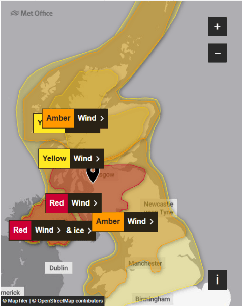
- Storm Éowyn (2025): Éowyn is bringing hurricane-force winds that have already knocked over the weather station here at MM0ZIF,
These events highlight the importance of identifying sting jets in forecasts to minimize their impact.
Why Are Sting Jets Hard to Predict?
Predicting sting jets is challenging due to their:
- Localized Nature: Unlike the broad wind fields of typical cyclones, sting jets are concentrated in a small area, making them difficult to detect.
- Short Duration: They usually last only a few hours, providing a limited window for issuing warnings.
- Complex Formation: The interaction of dry intrusion, evaporative cooling, and cyclone dynamics requires high-resolution weather models to identify.
Meteorologists are continuously improving forecasting techniques, using advanced numerical models and satellite data to better understand and predict sting jets.
How to Stay Safe During a Sting Jet Event
If a sting jet is forecasted or suspected during a storm, it’s vital to take precautions:
- Stay Informed: Monitor weather forecasts and warnings from reliable sources like the Met Office or NOAA.
- Secure Property: Anchor loose outdoor items and reinforce vulnerable structures.
- Avoid Travel: High winds can make roads dangerous and cause flying debris.
- Prepare for Power Outages: Keep emergency supplies on hand, including flashlights, batteries, and non-perishable food.
The Future of Sting Jet Research
As climate change influences global weather patterns, scientists are investigating whether sting jets will become more frequent or intense. Warming oceans and shifting atmospheric conditions could impact the behavior of extratropical cyclones, making sting jets a critical focus of future research.
Advances in computational power and satellite technology are helping meteorologists model these phenomena with greater accuracy. By improving our understanding of sting jets, we can enhance forecasting and minimize their impact on vulnerable communities.
Conclusion
Sting jets are a rare but powerful atmospheric phenomenon that can cause significant damage in a short time. Their formation is a testament to the complex dynamics of the Earth’s atmosphere, and their study is essential for improving storm preparedness and resilience. As we learn more about these hidden forces of nature, we can better protect ourselves from their destructive potential.
I have a weather Glossary here for anything you might find hard to understand, if it still isn’t explained please do not hesitate to message me and I will fill in the gaps and update the site. Remember everyone learns differently, and learning should be nurtured.
Tell us how can we improve this post?

Hi I am Marcus, MM0ZIF, a licenced Radio Amateur, Doctor of Musicology, amateur weather enthusiast. I over the years have been a Amateur Radio Tutor, Examiner, and a Regional Manager for the Radio Society of Great Britain.
This site is dedicated more towards Amateur Radio and Weather, with an angle on Technology too. I also maintain https://havenswell.com/ which is my other blog which is more aimed at cooking, hobbies and life in general as well as businness and networking.
- MM0ZIFhttps://mm0zif.radio/current/author/nimda_marcus/

- MM0ZIFhttps://mm0zif.radio/current/author/nimda_marcus/
- MM0ZIFhttps://mm0zif.radio/current/author/nimda_marcus/

- MM0ZIFhttps://mm0zif.radio/current/author/nimda_marcus/


