1. What Are Altocumulus Clouds?
- Altocumulus clouds are like the middle children of the cloud family—they exist between the lower-level cumulus and the high-flying cirrus. These cloudlets typically form at altitudes ranging from 2,000 to 7,000 meters (7,000 to 23,000 feet) above ground level1. That’s quite a sweet spot in the sky!
- They appear as small layers or patches of cloud, often resembling rounded clumps. Picture fluffy cotton balls arranged in bands or areas across the sky.
2. Appearance and Variety:
- Altocumulus clouds can wear different outfits. Sometimes they’re white, other times grey, and they might even have shaded sides. Their base height usually falls within the 7,000 to 18,000 feet range.
- The most common type is Altocumulus stratiformis, which looks like flat-bottomed puffy clouds tightly packed together, separated by tiny rivers of sky. These can cover the whole sky or appear in smaller patches.
- Ever seen lens-shaped clouds that seem straight out of a sci-fi movie? Those are Altocumulus lenticularis (also known as lenticular clouds). They often form over hilly areas and resemble—you guessed it—a UFO.
- Then there’s Altocumulus castellanus, which towers upward and can indicate instability. These puffy clouds might even lead to the formation of thunderstorms.
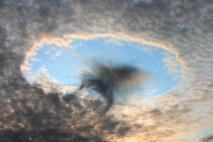
- Don’t forget Altocumulus floccus, which hangs out with castellanus. These cloudlets are slightly smaller and more ragged, often accompanied by virga (rain that evaporates before reaching the ground).
3. Weather and Precipitation:
- Altocumulus clouds are generally associated with settled weather. They’re like the reliable friend who rarely causes a fuss.
- While they’re mostly composed of droplets, they might also contain ice crystals. Precipitation from altocumulus clouds is rare, but if it does rain, it doesn’t reach the ground. Instead, you might see virga—a whimsical sight where rain evaporates before hitting the surface.
4. Fun Fact:
- Altocumulus clouds often create what’s known as a “mackerel sky.” Imagine a canvas of clumpy, fish-scale-like clouds—utterly mesmerizing!
So, next time you look up and spot those mid-level cloud heaps, give them a nod. They’re the unsung heroes of our skies, adding texture and intrigue to the atmospheric tapestry. 🌤️
Back to find out more about clouds here
Or back to the home of the website here
Tell us how can we improve this post?
Hi I am Marcus, MM0ZIF, a licenced Radio Amateur, Doctor of Musicology, amateur weather enthusiast. I over the years have been a Amateur Radio Tutor, Examiner, and a Regional Manager for the Radio Society of Great Britain.
This site is dedicated more towards Amateur Radio and Weather, with an angle on Technology too. I also maintain https://havenswell.com/ which is my other blog which is more aimed at cooking, hobbies and life in general as well as businness and networking.


