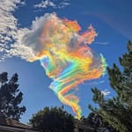
Besides being the weather’s cryptic fortune tellers, cirrostratus clouds have a secret talent: they can create colorful and sometimes eerie effects. When they take the form of thin cirrostratus nebulosus, they play with sunlight or moonlight, producing halos. It’s like the sky saying, “Hey, I’m not just a cloud; I’m a celestial mood ring!” 🌈
1. The Basics:
- Imagine cirrostratus as the sky’s sheer chiffon scarf. It’s like the atmosphere decided to accessorize with elegance. These clouds form a delicate veil that covers all or part of the sky, leaving us squinting like confused stargazers.
- Height of Base: Cirrostratus hangs out way up there—between 20,000 and 40,000 feet. That’s like cloud VIP territory. They’re so high, even birds look up and say, “Dude, you’re practically in space.”
2. Halo Chic:
- Cirrostratus sometimes plays cosmic dress-up. It produces white or colored rings, spots, or arcs of light around the Sun or Moon. These celestial bling-bling are called halo phenomena. It’s like the sky saying, “I woke up like this—flawless.”
- Sometimes cirrostratus is so thin that the halo is the only hint it’s there. It’s like the ultimate game of celestial peekaboo.
3. Weather Whisperers:
- Cirrostratus isn’t just a pretty face. It’s the meteorological fortune cookie. Pay attention! If you spot it:
- Cirrostratus Nebulosus: A uniform veil-like layer. Featureless, composed entirely of ice. It’s like the sky’s whispering, “Expect something, but I won’t spill the weather beans.”
- Cirrostratus Fibratus: Wispy strands all tightly knitted together. Imagine animal fur—classy yet mysterious. If you see this, stratus clouds might follow, bringing light drizzle. It’s like the sky’s subtle wink.
4. Contrail Couture:
- Cirrostratus can form through contrails—the vapor trails left by planes as they fly through the dry upper troposphere. These streaks spread out and become cirrus, cirrostratus, and cirrocumulus. It’s like aviation’s version of cloud origami.
5. Weather Clues (Because Cirrostratus Is a Gossip):
- If cirrostratus nebulosus shows up, brace yourself. An incoming warm front will likely bring persistent rain within a day. It’s like the sky’s saying, “Raindrops, you’re invited!”
- But if you spot cirrostratus fibratus, it’s more chill. Stratus clouds might follow, but they’ll bring only light drizzle. It’s like the sky’s saying, “Grab a tiny umbrella, just in case.”
6. Fun Fact (Because Even Clouds Need Fun):
- Cirrostratus clouds warm the Earth. Yep, they’re like the cozy blankets of the atmosphere. But here’s the twist: a warming Earth might produce more cirrostratus clouds, creating a self-reinforcing loop. It’s like climate change’s subtle fashion statement.
So, next time you crane your neck skyward and spot those icy veils, give a nod to cirrostratus. It’s the cloud equivalent of a whispered secret—a touch of magic in the vast expanse. ☁️✨
Feel free to share this cloud wisdom at your next socially distant stargazing soirée. Impress your friends, and who knows—you might become the resident cloud guru! 🌌🌈
Cirrostratus Cloud Derivatives:
Varieties
- Cirrostratus undulatus: Shows wave-like fine ripples
- Cirrostratus duplicatus: Consists of more than one layer
Supplementary Features
Cirrostratus produces no precipitation or virga and is not accompanied by any accessory clouds.
Genitus and Mutatus Forms
- Cirrostratus fibratus cirrocumulogenitus: Forms when cirrocumulus flattens and loses some of its structure
- Cirrostratus fibratus cumulonimbogenitus: Develops when the cirriform top of a mature thundercloud spreads and flattens
- Cirrostratus fibratus cirromutatus or cirrocumulomutatus: Results from a complete transformation of cirrus and cirrocumulus
- Cirrostratus nebulosus altostratomutatus: Forms when a high grey nebulous altostratus layer thins out
Weather Implications
- Often signals the approach of a warm front
- May indicate precipitation within 12 to 24 hours
- If broken fibratus, it can mean a weak front with potential for drizzle or snow grains
Identification Tips
- Coverage: Often covers the entire sky4
- Transparency: Nearly transparent, allowing sun or moon to be seen clearly
- Halo effect: Can produce a circular halo around the sun or moon
- Altitude: Forms at high altitudes, typically above 20,000 feet
Understanding these characteristics and derivatives of Cirrostratus clouds can help in weather prediction and cloud identification.
Learn more about these frosty feather boas and their high-altitude escapades! 🌦️🔍
I hope you enjoyed our whimsical exploration of cirrostratus clouds! If you have more cloud curiosities or need weather-related banter, just ask—I’m here to sprinkle stardust on your screen! ☁️❄️
For more Cloud information go Here, or back to the homepage here
Hi I am Marcus, MM0ZIF, a licenced Radio Amateur, Doctor of Musicology, amateur weather enthusiast. I over the years have been a Amateur Radio Tutor, Examiner, and a Regional Manager for the Radio Society of Great Britain.
This site is dedicated more towards Amateur Radio and Weather, with an angle on Technology too. I also maintain https://havenswell.com/ which is my other blog which is more aimed at cooking, hobbies and life in general as well as businness and networking.


