

Introduction: Sailing with Sir Francis Beaufort
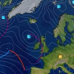
Ahoy, landlubbers and weather enthusiasts! Today, we’re setting sail on a gusty adventure across the high seas of wind measurement. Our trusty compass? The Beaufort Wind Scale, was named after the dashing Sir Francis Beaufort of the British Royal Navy. Picture him standing on the deck, tricorn hat rakishly tilted, luckily avoiding another outbreak of Scurvy, squinting at the horizon. His mission? To turn wind into poetry. 🌬️🏴☠️
The Beaufort Scale, developed by Sir Francis Beaufort in 1805, is a system for estimating wind speeds based on observable conditions at sea or on land. Here’s a brief overview of its history:
Origins
- Sir Francis Beaufort: An Irish hydrographer and Royal Navy officer, Francis Beaufort created the scale to standardize wind speed descriptions for maritime navigation. Beaufort was born in 1774 and had a significant career in naval service, during which he developed various tools and methods for navigation.
Development
- Early Career: In the early 19th century, navigation and weather forecasting relied heavily on subjective descriptions of wind conditions, which were inconsistent and varied among sailors. Beaufort recognized the need for a standardized system that could improve safety and efficiency in maritime operations.
- First Version: In 1805, Beaufort introduced his scale in a report for the British Admiralty. The original scale had 13 levels, ranging from 0 (calm) to 12 (hurricane), and was based on the impact of the wind on the sea. Each level described observable effects, such as the height of waves and the appearance of foam.
Adoption and Revisions
- Royal Navy: The scale was initially used by the British Royal Navy and quickly gained acceptance for its practical utility in navigation and weather reporting.
- International Adoption: Over time, the Beaufort Scale was adopted by other navies and meteorological organizations around the world. It became a standard tool for marine weather forecasting and has been included in various maritime and meteorological manuals.
- Revisions: Although the scale has remained largely unchanged, it has been adapted and refined to fit different contexts. For example, the wind speeds associated with each level have been adjusted to better reflect modern measurement techniques and instruments.
Modern Usage
- Meteorology: Today, the Beaufort Scale is used not only in maritime contexts but also in land-based weather reporting. It provides a simple, visual way to describe wind conditions and their effects, making it accessible to both professionals and the general public.
- Educational and Historical Importance: The Beaufort Scale is often used in educational contexts to teach about historical methods of weather observation and the development of meteorological tools.
Overall, the Beaufort Scale is a testament to the practical needs of navigation and weather forecasting in the early 19th century and continues to be a useful tool for describing wind conditions in a straightforward manner.
Sources:
Now, go forth, my weather-savvy mateys! May your sails be full, your compass true, and your Beaufort numbers as wild as a pirate’s shanty! 🌊⚓🌪️
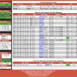
| Beaufort Scale | Wind Speed (knots) | Effects |
|---|
| 0 – Calm | < 1 | Sea is mirror-like; smoke rises vertically. |
| 1 – Light Air | 1-3 | Small ripples; smoke drifts slowly. |
| 2 – Light Breeze | 4-6 | Small wavelets; whitecaps appear; leaves and twigs in constant motion. |
| 3 – Gentle Breeze | 7-10 | Large wavelets; whitecaps; dust and loose paper are raised. |
| 4 – Moderate Breeze | 11-16 | Small waves; more whitecaps; dust and leaves blown around. |
| 5 – Fresh Breeze | 17-21 | Moderate waves; larger whitecaps; difficult to walk against the wind. |
| 6 – Strong Breeze | 22-27 | Large waves; sea begins to foam; branches of trees in constant motion. |
| 7 – Near Gale | 28-33 | High waves; considerable foam and spray; whole trees in motion. |
| 8 – Gale | 34-40 | Very high waves; sea surface greatly reduced visibility; walking difficult. |
| 9 – Severe Gale | 41-47 | Exceptionally high waves; widespread foam; extensive damage. |
| 10 – Storm | 48-55 | Extremely high waves; storm force wind; considerable structural damage. |
| 11 – Violent Storm | 56-63 | Exceptionally high waves; severe damage; very severe conditions. |
| 12 – Hurricane | > 64 | Sea completely white with foam; widespread severe damage; hurricane force winds. |
Tell us how can we improve this post?

Hi I am Marcus, MM0ZIF, a licenced Radio Amateur, Doctor of Musicology, amateur weather enthusiast. I over the years have been a Amateur Radio Tutor, Examiner, and a Regional Manager for the Radio Society of Great Britain.
This site is dedicated more towards Amateur Radio and Weather, with an angle on Technology too. I also maintain https://havenswell.com/ which is my other blog which is more aimed at cooking, hobbies and life in general as well as businness and networking.
- MM0ZIF

- MM0ZIF
- MM0ZIF
- MM0ZIF

- MM0ZIF

- MM0ZIF

- MM0ZIF
- MM0ZIF
- MM0ZIF
- MM0ZIF
- MM0ZIF

- MM0ZIF

- MM0ZIF

- MM0ZIF
- MM0ZIF

- MM0ZIF
- MM0ZIF

- MM0ZIF
- MM0ZIF

- MM0ZIF

- MM0ZIF

- MM0ZIF

- MM0ZIF
- MM0ZIF

- MM0ZIF

- MM0ZIF

- MM0ZIF

- MM0ZIF

- MM0ZIF

- MM0ZIF
- MM0ZIF
- MM0ZIF

- MM0ZIF

- MM0ZIF

- MM0ZIF

- MM0ZIF
- MM0ZIF
- MM0ZIF

- MM0ZIF
- MM0ZIF
- MM0ZIF

- MM0ZIF
- MM0ZIF

- MM0ZIF

- MM0ZIF
- MM0ZIF
- MM0ZIF

- MM0ZIF

- MM0ZIF
- MM0ZIF

- MM0ZIF
- MM0ZIF
- MM0ZIF

- MM0ZIF
- MM0ZIF

- MM0ZIF
- MM0ZIF
- MM0ZIF

- MM0ZIF

- MM0ZIF

- MM0ZIF

- MM0ZIF
- MM0ZIF

- MM0ZIF

- MM0ZIF
- MM0ZIF

- MM0ZIF

- MM0ZIF

- MM0ZIF

- MM0ZIF

- MM0ZIF

- MM0ZIF

- MM0ZIF

- MM0ZIF

- MM0ZIF

- MM0ZIF

- MM0ZIF

- MM0ZIF

- MM0ZIF

- MM0ZIF
- MM0ZIF
- MM0ZIF

- MM0ZIF

- MM0ZIF

- MM0ZIF

- MM0ZIF

- MM0ZIF
- MM0ZIF
- MM0ZIF
- MM0ZIF
- MM0ZIF
- MM0ZIF
- MM0ZIF
- MM0ZIF
- MM0ZIF
- MM0ZIF
- MM0ZIF
- MM0ZIF

- MM0ZIF

- MM0ZIF

- MM0ZIF

- MM0ZIF

- MM0ZIF

- MM0ZIF

- MM0ZIF

- MM0ZIF
- MM0ZIF

- MM0ZIF

- MM0ZIF

- MM0ZIF

- MM0ZIF

- MM0ZIF

- MM0ZIF

- MM0ZIF

- MM0ZIF

- MM0ZIF

- MM0ZIF

- MM0ZIF

- MM0ZIF

- MM0ZIF
- MM0ZIF

- MM0ZIF

- MM0ZIF

- MM0ZIF
- MM0ZIF
- MM0ZIF

- MM0ZIF
- MM0ZIF

- MM0ZIF
- MM0ZIF
- MM0ZIF

- MM0ZIF

- MM0ZIF

- MM0ZIF

- MM0ZIF

- MM0ZIF

- MM0ZIF

- MM0ZIF
- MM0ZIF

- MM0ZIF

- MM0ZIF

- MM0ZIF

- MM0ZIF

- MM0ZIF
- MM0ZIF
- MM0ZIF

- MM0ZIF

- MM0ZIF
- MM0ZIF

- MM0ZIF
- MM0ZIF
- MM0ZIF
- MM0ZIF

- MM0ZIF
- MM0ZIF
- MM0ZIF

- MM0ZIF
- MM0ZIF

- MM0ZIF

- MM0ZIF
- MM0ZIF
- MM0ZIF
- MM0ZIF

- MM0ZIF
- MM0ZIF
- MM0ZIF

- MM0ZIF

- MM0ZIF
- MM0ZIF

- MM0ZIF
- MM0ZIF

- MM0ZIF
- MM0ZIF

- MM0ZIF
- MM0ZIF

- MM0ZIF
- MM0ZIF

- MM0ZIF
- MM0ZIF


